In this extract from Mars Manual, published by Haynes Publishing, author David M. Harland explores how our species first reached out to put human-made objects on our red, rocky neighbour.
Sending probes through space to inspect Mars directly, initially during flybys and later from orbit, showed it to be very different to expectation. It was nothing like a small version of Earth.
Its ancient surface looked so desolate that the planet lost much of its popular appeal. Nevertheless, it was a paradise for scientists with an interest in comparative planetology.
In 1925 the German mathematician Walter Hohmann calculated trajectories from Earth to Mars and discovered that the minimum energy ‘transfer’ would depart on an elliptical path which was tangential to Earth’s orbit around the Sun and had an aphelion tangential to the orbit of Mars.
- Wernher von Braun's forgotten mission to Mars
- A guide to the moons of Mars
- Evidence of liquid water on Mars
The passage would take about 250 days. In that time Mars would travel an arc of 130° around its orbit.
The optimal ‘launch windows’ opened shortly prior to opposition and lasted several weeks.
Hohmann identified several other trajectories that required greater expenditures of energy.
Of course, this scheme depended on the capability of the rocket.
Since Mars has an elliptical orbit whose closest point of approach to Earth varies greatly, the minimum being about 56 million km, it would be best to attempt such a voyage at a perihelic opposition.
Early frustrations
Unfortunately the technology for travelling in space did not exist at the very close perihelic opposition of 1956, but having begun the Space Age on 4 October 1957 by launching Sputnik, the Soviet Union decided to dispatch two probes during the October 1960 window.
The plan was to insert a probe into a ‘parking’ orbit around Earth as a preliminary to firing a small ‘escape’ stage to achieve an interplanetary trajectory.
Unfortunately, the launch vehicles malfunctioned and the probes failed to reach parking orbit.
Two more probes were prepared for the 1962 window.
The first was stranded in Earth orbit by the failure of its escape stage, but the second, launched on 1 November, succeeded and was announced as Mars 1.
Although it suffered attitude control problems and its radio fell silent after several months, the fact that it passed within 200,000km of its objective in June 1963 made it a great achievement.
Meanwhile in America, the National Aeronautics and Space Administration (NASA) had attempted two interplanetary missions to investigate Venus.
The first was lost at launch but Mariner 2 became the first to provide close observations of another planet when it made a 35,000km flyby of its target on 14 December 1962.
Although the opposition of Mars in March 1965 was aphelic and the Hohmann transfer was not favourable, missions were still attempted.
The Soviets had a new design of interplanetary spacecraft.
They launched Zond 2 on 30 November 1964.
It fell silent in transit and flew past the planet on 6 August at a range estimated to have been as much as 650,000km.
The first success
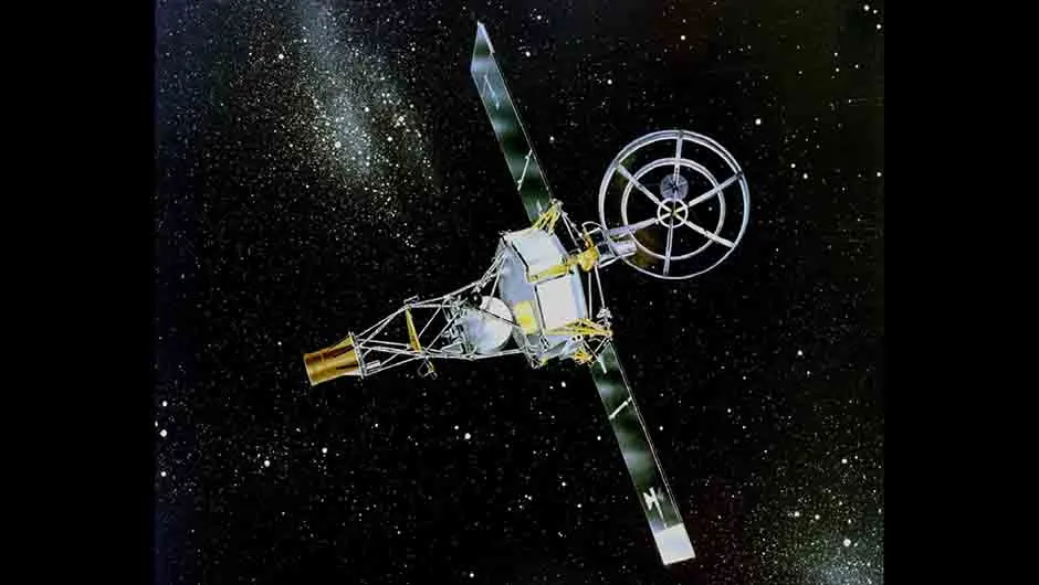
Although NASA lost one probe at launch in the 1964 window for Mars it was able to undertake modifications and dispatch Mariner 4 on 28 November, a few days before that year’s window closed.
There were several rules for the trajectory during the brief encounter.
Firstly, neither Mars nor its two moonlets could be permitted to obstruct the spacecraft’s view of the star by which the vehicle orientated itself; nor could it fly through the shadows of any of these bodies.
As the 228-day trajectory was designed to catch up with the planet, the observations would be of the trailing hemisphere.
The post-encounter trajectory had to pass behind the planet (as viewed from Earth) to allow the manner in which the radio signal was cut off by the limb of the planet to yield the first definitive measurement of the density of the atmosphere.
A second such measurement would be obtained when the craft emerged from the leading limb.
Crucially, this occultation had to occur when the planet was above the horizon of the receiving antenna at the Goldstone station in California.
A mid-course correction on 5 December trimmed the initial 240,000km ‘miss distance’ to the intended 10,000km flyby.
In addition to arranging the timing, this manoeuvre determined the surface features that would be in the field of view of the camera at the time of closest approach.
The objective was to obtain pictures comparable in resolution to contemporary telescopic pictures of the Moon.
It had initially been intended to inspect the prominent dark feature Syrtis Major, but the delayed launch ruled this out.
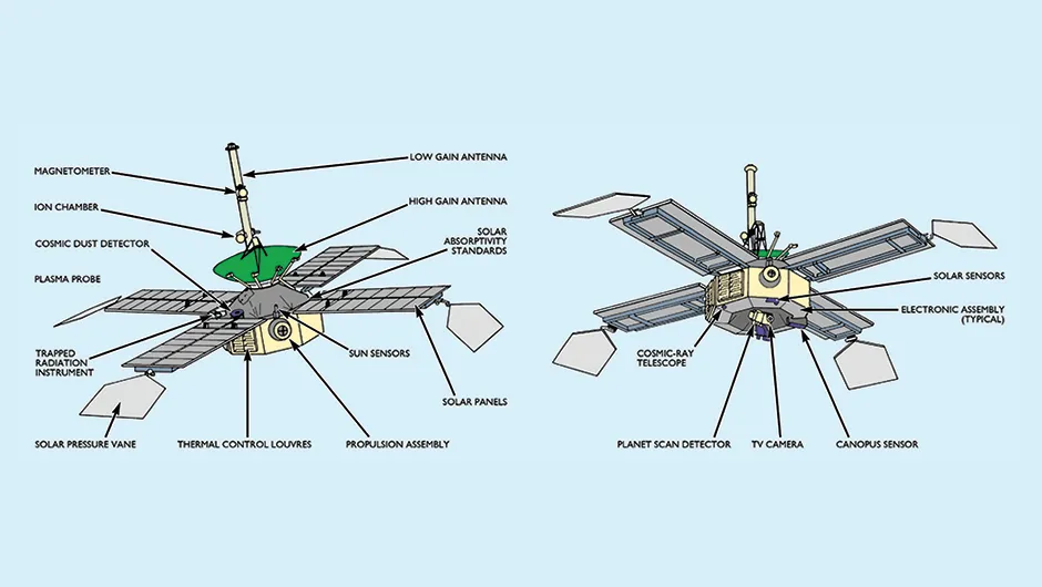
On the octagonal base of Mariner 4 was a vidicon imaging system carried on a platform which could be rotated through 180°.
The system was powered up 6hr prior to the encounter on 14 July 1965 to allow time to troubleshoot any problems – diagnosing a fault and issuing recovery actions needed to be prompt, since the light-speed travel time over such a distance was 12min.
An hour out, the platform rotated until its wide-angle sensor noted the presence of the planet, at which time it centred the camera on the target.
The imaging sequence was started when the narrow-angle sensor detected the planet about half an hour later.
The image from an f/8 Cassegrain telescope that had a 4cm aperture and a 30cm focal length was projected onto a phosphor screen to be digitised into an array of 200 x 200 pixels, each encoding a 6-bit greyscale value.
The data from the particles and fields instruments was transmitted in real time but the images were stored on a 100m loop of magnetic tape.
The exposure time had been pre-set at 1/20th of a second; this being the best estimate on the basis of predicted illumination.
It took 24sec to read out the image from the vidicon and another 24sec to clear the screen, hence pictures could be taken no more rapidly than once every 48sec.
A rotating shutter alternated blue-green and orangered filters to enhance the contrast in the greyscale and also to emphasise the colour differences of the albedo features on the planet.
About 12hr after the encounter, the tape began to replay the images.
At 8.33bit/sec using the 10W transmitter, it required 8hr 20min to replay the 240,000 bits in each image.
In fact the effective rate was one frame every 10hr, because each frame was accompanied by some engineering data.
Not what was expected!
Taken from a range of 16,500km, the first frame showed the planet’s limb and the blackness of space. The engineers were ecstatic, because this confirmed that the camera had properly locked onto the planet.
As the other frames were processed there was disappointment.
Despite having used filters to highlight the contrast on the planet’s surface, most of the 22 images were bland due to ‘flare’ in the optics, and the remainder were black.
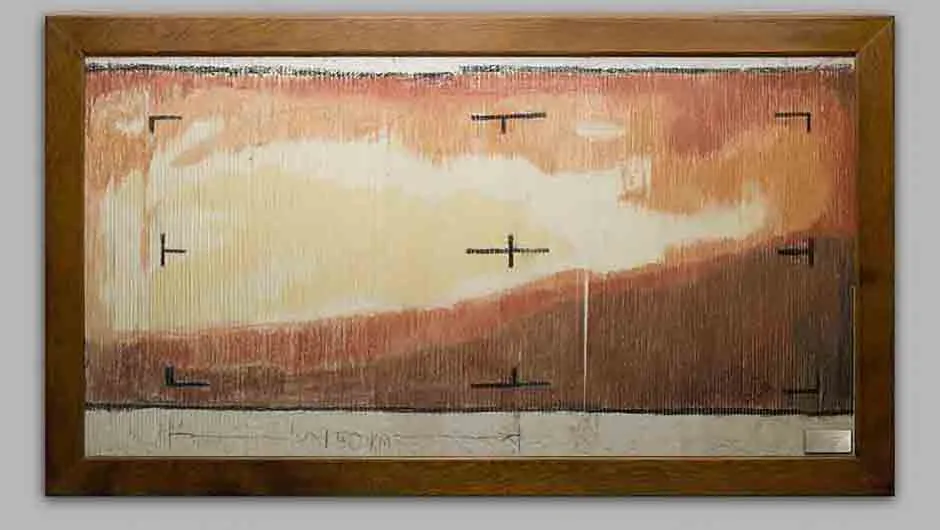
Fortunately, the Jet Propulsion Laboratory (JPL) of the California Institute of Technology in Pasadena, which operated deep space missions for NASA, had a computer algorithm to ‘enhance’ digital imagery in order to ‘stretch’ the contrast, and when this was applied some surface details became evident.
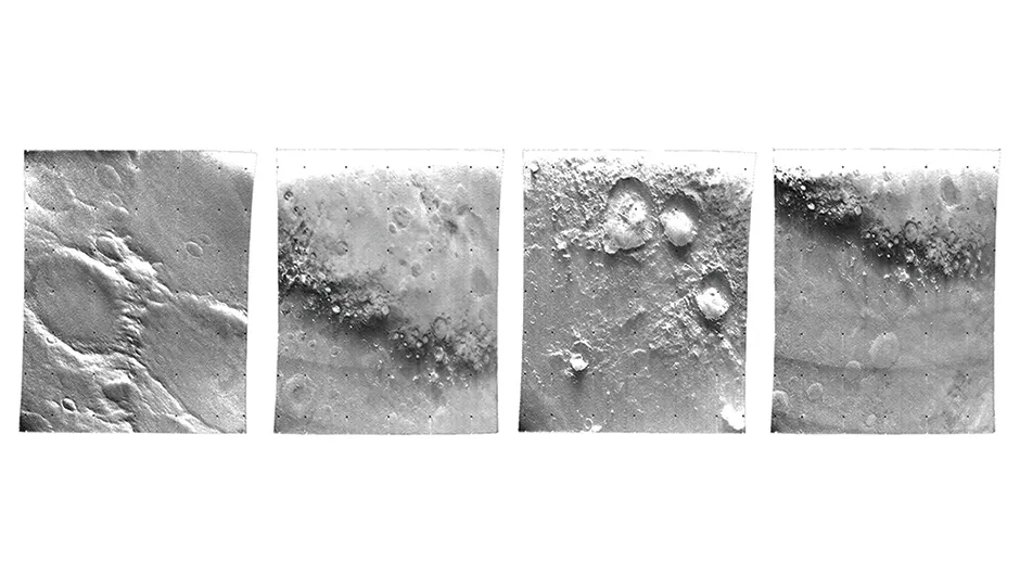
The imaging sequence began with a view looking northwards across the limb at a longitude of 190° (on Mars longitudes are west of the meridian) and tracked southeast and across the equator at longitude 180° to about 52° south, where it swung north and crossed the terminator.
In all, it spanned some 90° of longitude. In the first few frames, the surface appeared to be blotchy with hints of large circular features.
On frame #7 it became apparent that these were craters, which were depicted in greater clarity with each successive frame.
The crater, 120km in diameter on frame #11, which was taken from a range of 12,500km, became the iconic image of the mission.
The final frame to show surface detail was #15.
Although the contrast on the terminator would have emphasised the surface relief, the sensor to increase the exposure as the field of view darkened failed to operate.
Although the imaging system was marred by flare, it had achieved its primary objective of revealing the nature of the Martian surface in a swathe covering about 1% of the planet.
The fact that craters were present on a variety of albedo features familiar to telescopic observers implied the entire surface of Mars was billions of years old, like that of the Moon.
Around 1950, Clyde William Tombaugh had considered the possibility of Mars having suffered impacts that would make big craters.
He imagined that the linear streaks that appeared to radiate from the features that Lowell called oases might be deep cracks in the crust produced by the shock of the impacts that excavated the nodes.
Ralph Belknap Baldwin and Ernst Julius Öpik independently came up with similar ideas. At that time, however, there had not seemed to be any way of ever finding out whether the oases really were craters.
Although the flyby images established the presence of craters, these clearly bore no relationship to Lowell’s map. Indeed, by happy circumstance frame #11 should have recorded a canal if such things existed.
Space writer Eric Burgess drew attention to the fact that the 120km crater (which was named ‘Mariner’ in honour of the spacecraft) lies on the line of a canal.
Although there are several narrow parallel linear features, these did not suggest an artificial structure.
The final ‘nail in the coffin’ for the prospect of life on Mars was yielded by the occultation experiment.
The strength of the spacecraft’s radio signal was carefully monitored as it flew behind the planet’s limb an hour and a half after the point of closest approach and again as it emerged from the far side an hour or so later to obtain refractivity profiles in daylight at a latitude of 55° south and in darkness at 60° north.
This enabled the chemical composition, temperature, and pressure to be calculated in terms of altitude. The results indicated surface pressures in the range 4–6 millibars.
In view of the discovery by Mount Wilson that the partial pressure of carbon dioxide at the surface was 4 millibars, the occultation data meant the atmosphere was at least 95% carbon dioxide.
Liquid water would certainly not be stable on the surface at such a low pressure.
The nitrogen that had been presumed by analogy with Earth to make up the remainder of the supposed ‘25 millibar atmosphere’ was actually present only in trace amounts.
Furthermore, Mars was much colder than expected because after sunset the surface would soon radiate the heat absorbed from the Sun.
Although it had little water vapour in absolute terms, the fact that the planet was so cold meant that at night the atmosphere was near to its ‘saturation point’.
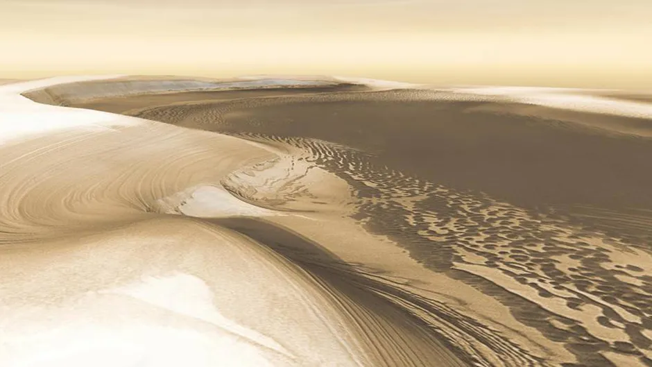
The finding that the poles plunged down to temperatures below –128°C revived the long-discarded idea of the seasonal caps being a frost of carbon dioxide rather than water ice.
Finally, it was realised the low pressure was no coincidence because the carbon dioxide in the atmosphere and in the polar caps was in a state of equilibrium.
Other instruments on the spacecraft established that if Mars had a magnetic field it was exceedingly weak and unable to create a magnetosphere to ward off the solar wind.
The fact that the surface was irradiated by solar ultraviolet as well as energetic particles from the solar wind rendered most unlikely the prospect of life even as ‘simple’ as lichen.
In view of the rarefied atmosphere, the inhospitable surface conditions, and the seemingly inert ancient crust, The New York Times made a play on Mars’s moniker of the Red Planet by dubbing it the Dead Planet and, almost overnight, interest plummeted.
Following up
NASA sent another two probes in 1969.
The imaging system was augmented by a wideangle lens to obtain context for the narrower frames, the tape recorder could store more images, and the communications system could transmit them at a rate of 16.2kbit/sec, which was almost 2,000 times faster than previously.
During its far-encounter sequence Mariner 6 obtained a series of 50 images to document the sunlit hemisphere of the planet as it turned on its axis.
Even the first picture from a range of 1 million km was better than that of a terrestrial telescope.
On 31 July, the probe took 25 images in an equatorial swathe which ran from 320° to 60° of longitude with the point of closest approach 3,500km above Sinus Meridiani.
On viewing the early results, scientists decided that the far south was so intriguing that they reprogrammed Mariner 7 to obtain an additional eight images to extend its near-encounter coverage into that region. Mariner 7 took 91 images during its farencounter sequence.
There was some concern when the vehicle fell silent, but contact was regained and during its flyby on 5 August it acquired 33 images in two swathes, one in the southern hemisphere close to the meridian and the other crossing the equator and running from 100° to 20° of longitude.
An analysis of the craters found their depthto-diameter ratios to be different to those of the highlands of the Moon.
Craters less than about 20km wide are simple bowls with ‘sharp’ profiles and raised rims, but the larger ones appear ‘shallower’ than their lunar counterparts, having complex central peaks, terraced inner walls, degraded rims and ejecta blankets, and floors that have been levelled by various infill materials.
There was a striking paucity of chains of secondary craters made by ejecta from major impacts.
A significant result of the 1969 flybys was the realisation that craters are not ubiquitous. Some areas were classified as ‘chaotic’ and others as ‘featureless’.
Some assumptions of telescopic observers proved to be wide of the mark.
A bright circular area called Hellas that had often brightened to resemble an offset polar cap had been interpreted as a plateau that attracted a covering of snow in winter.
The pressure data revealed it to be a very deep cavity. It was inferred that when its floor was masked by clouds, it appeared bright and featureless.
Another intriguing feature in the far-encounter imagery was a large circular structure where Schiaparelli had often mapped a bright spot that he named Nix Olympica (Snows of Olympus).
The occultation data from these probes verified that the pressure profile of the atmosphere is shallower because Martian gravity is weaker. The surface at Sinus Meridiani was 6.5 millibars.
However, the fact that the southern latitudes were 3.5 millibars implied this was elevated terrain.
It was decided to adopt 6.2 millibars as a sort of ‘sea level’ reference altitude.
This pressure was significant for being the ‘triple point’ of water.
In fact, given the geographical and seasonal variations, the mean surface pressure on Mars is near this value.
Water cannot exist in its liquid phase at lower pressures.
The temperature at the south pole was measured to be –123°C, reinforcing the argument that the seasonal polar caps were frozen carbon dioxide because this was close to the ‘frost point’ of carbon dioxide.
Between them, the three NASA flybys documented about 10% of Mars at a moderate resolution.
Their data repudiated the soundly reasoned impression of the Red Planet, turning the presumed cold dry world that harboured vegetation into one that still bore the scars of ancient impacts, had an atmosphere too thin for surface water, and was devoid of life.
A global perspective
Nevertheless, geoscientists were eager to insert a vehicle into orbit to carry out global mapping.
In fact, it would be better to employ two spacecraft.
When we view the Moon at its ‘full’ phase we see only albedo variations. At other phases, shadows at the terminator indicate surface relief.
No telescopic study of Mars had ever hinted at topography on its terminator, which was why observers had focused on mapping albedo features.
A craft in orbit would be able to view the surface under a variety of illuminations but whereas a high point over the illuminated hemisphere would favour albedo studies, a low point over the terminator was required to undertake topographic mapping.
Accordingly, NASA assigned Mariner 8 a highly inclined orbit that dipped low over the terminator to map 70% of the planet at high resolution, while Mariner 9, in an almost equatorial orbit at high altitude, would monitor the seasonal albedo variations.
As these new spacecraft would require a rocket engine and the propellant to slow down in order to enter orbit around Mars, they would be much heavier than their predecessors.
Fortunately, the perihelic opposition of 1971 would minimise the energy requirements.
When Mariner 8 was lost at launch, the plan was redesigned to allow a single spacecraft to make as many observations as possible from a compromise orbital inclination of 65° which would provide illumination at shallower angles than would be ideal for albedo studies and higher than was ideal for mapping the topography.
To everyone’s relief the reprogrammed Mariner 9 was successfully dispatched on 30 May 1971.
Dust storm!
Astronomers had seen ‘yellow clouds’ sometimes blanking out large areas of the planet’s surface. In 1909 Antoniadi had seen one that lasted for several days.
In 1911 he saw another that rapidly expanded to mask a large part of the southern hemisphere for several months.
Further observations implied they were fine dust stirred up by the strong winds created by differential solar heating in the southern hemisphere at perihelion.
In February 1971, Charles Franklin Capen in Flagstaff predicted that a major dust storm was likely to occur during that year’s opposition, and warned that this might interfere with the forthcoming orbital mapping mission.
On 21 September a storm did indeed develop.
It was first photographed by Gregory Roberts in South Africa, and by 27 September it hid a wide area to the west of Hellas.
By the end of the first week of October the mid-southern latitude zone was masked, and by the end of the month the entire globe was obscured!
The Soviet Union had launched a pair of spacecraft to Mars, each of which released a descent probe 4hr prior to inserting itself into orbit.
Mars 2 entered the intended 1,280 x 24,900km orbit on 27 November but its radio link was so poor that little usable data was received.
Its probe penetrated the atmosphere at a steeper angle than planned and struck the surface before it could deploy its parachute.
Despite suffering a propellant leak, on 2 December Mars 3 was able to limp into an orbit far more elliptical than planned, with a very high apoapsis.
Thus its opportunities for observing the planet were severely limited, and in any case it was unable to see anything due to the dust storm.
The most useful data came from radio occultations.
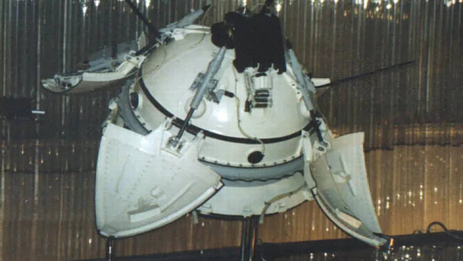
The Mars 3 probe entered the Martian atmosphere at 5.7km/sec at an entry angle of less than 10°. The drogue parachute was deployed.
This drew out the main parachute.
The heat shield was jettisoned and the radar switched on.
At a height of 20 to 30m and falling at 60 to 110m/sec, the parachute was discarded and a small rocket lifted it away from the lander.
Meanwhile, the lander fired its own retrorockets.
After an entry and descent phase lasting a little over 3min the lander touched down at a speed of 20.7m/sec.
The foam cover that had protected against the shock of impact was ejected and four petals opened.
Then 90sec after landing, the capsule began to transmit to its parent, which was heading for orbit insertion.
When the orbiter replayed to Earth several hours later, the transmission from its lander proved to have lasted less than 20sec.
The partial image is essentially noise.
Furthermore, because the data collected by the lander during its descent was stored for later transmission, that was lost as well.
The consensus is that the probe failed for some reason, but some engineers believe their lander worked properly and it was the orbiter’s relay that failed.
The lander plus its parachute, heat shield and retrorocket might have been spotted in a super-high-resolution image obtained by a NASA orbiter in November 2007 but the identification is not certain.
Poking out of the dust
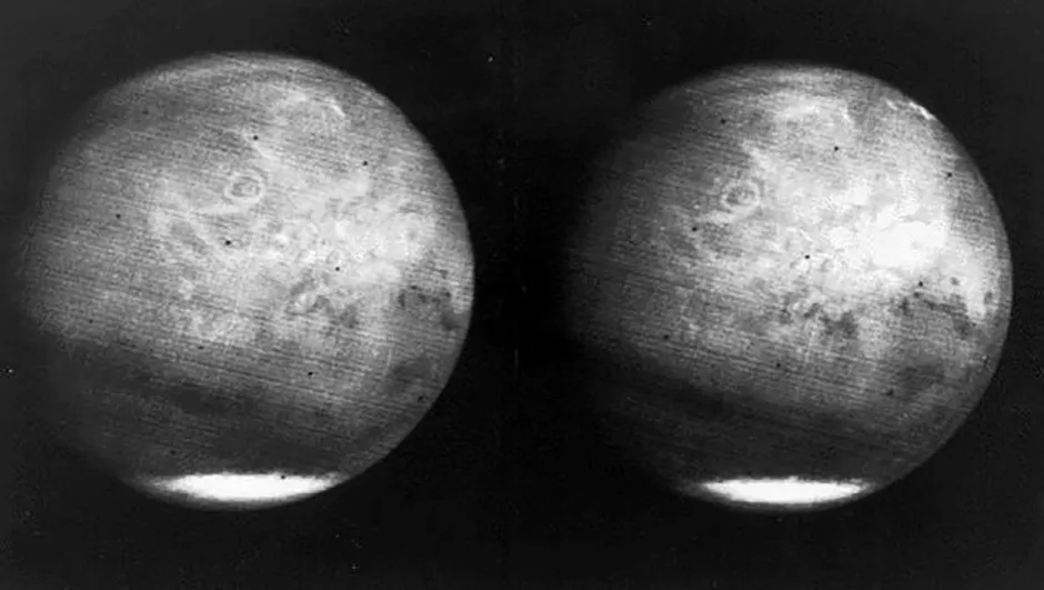
As Mariner 9 initiated its far-encounter imaging on 10 November, one week out, the only features comprised the south polar cap and four fuzzy dark spots. One corresponded to Nix Olympica.
The others, in the Tharsis area to the southeast, were spaced about 700km apart on a line running southwest to northeast which crossed the equator.
They were labelled neutrally as ‘North Spot’, ‘Middle Spot’ and ‘South Spot’.
On 14 November Mariner 9 became the first human artefact to achieve orbit around Mars. Each time the craft crossed the limb, its radio signal was carefully monitored to characterise the dust-laden atmosphere.
With nothing else to look at, the cameras were trained on the dark spots. As the dust started to clear, a large circular structure emerged in each case.
Once the dust had cleared, Nix Olympica was seen to be a shield volcano rising 25km above its surroundings, with its periphery marked by a scarp 8km tall.
The other spots also proved to be volcanoes with summit calderas.
In contrast to the impression gained from the cratered terrain imaged by the flyby missions, it was now evident the planet had undergone intense volcanism.
Although the infrared radiometer saw no ‘hot spots’ in the calderas to indicate current activity, subsequent high-resolution views of lava flows on the flanks were sufficiently lacking in impacts to suggest that the vents were active in geologically ‘recent’ times.
If so, then although the atmosphere is tenuous and dry today, from time to time it might become enriched by volcanic gases, including water vapour.
Mars revealed, finally In January 1972, with the atmosphere clear again, Mariner 9 refined its orbit to start mapping.
This began in the southern hemisphere and migrated northward, producing a series of startling discoveries.
In retrospect, it was evident that by happenstance of timing, the three flyby missions had passed over the most lunar-like portions of the surface.
There were sinuous channels in the southern cratered terrain, some with a dendritic pattern.
As the coverage crossed the equator, a canyon network was revealed that extended one-fifth of the way around the equator.
Vast channels drained into the Chryse region, which was part of a low-lying plain that formed much of the northern hemisphere.
More frustrations
The Soviets exploited the 1973 window for Mars but the planetary alignment was not as favourable as in 1971 and the landers had to be sent independently of the orbiters.
The vehicles that ferried the landers were to make flybys after releasing their payloads. Unfortunately, this flotilla produced meagre results.
A propellant leak prevented Mars 4 from braking, but it provided some useful pictures while making a 2,000km flyby.
Mars 5 successfully entered an orbit that was almost synchronised with the planet’s rate of rotation but an air leak from its instrument compartment curtailed its operation shortly after it had begun imaging activities.
The landers fared no better.
Mars 6 transmitted engineering and atmospheric data during its descent, then struck the surface at an unsurvivable 60m/sec.
And Mars 7, malfunctioning immediately after being released, missed the planet.
The dejected Soviet engineers decided to give up on Mars for the immediate future.
This extract is republished from Mars Manual by Haynes Publishing under written permission.