Nothing affects our ability to view the night sky more than the weather. Unless the sky conditions are favourable, hands-on astronomy is impossible, so the ability to recognise a potentially good opportunity for viewing or imaging in advance is very useful indeed.
But what constitutes good weather conditions for astronomy?
A cloudless sky is paramount – with a reasonable expectation that the conditions will remain clear long enough for setting up, cooling down and the observing session itself.
We have all experienced the frustration of setting up our equipment in readiness for an all-night session, only to have to pack it all away as the clouds roll in.
However, good transparency and ‘seeing’ are also important.
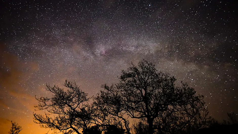
Transparency refers to the clarity of the atmosphere. If there is no moisture or dust in the sky, then the transparency is said to be good.
If there is a general haziness then the transparency is poor; colours will be muted and detail lost.
Transparency is usually better in the winter, when cold blasts from the Arctic bring pure, clean air towards the south, and worse in the summer because of inversion layers.
This is an increase in air temperature with altitude, which is the reverse of normal temperature in the lower atmosphere.
A quick glance outside to check for haziness will tell you if the transparency is good or bad.
 and a clear one (right). Credit: Pete Lawrence")
Seeing conditions refer to the steadiness of the atmosphere – twinkling stars may look beautiful to the naked eye but they are a sure sign of poor seeing. For more on this, read our guide Why do stars twinkle?
An unsteady atmosphere means detail will be blurred as celestial objects appear to shimmer and pulsate, which can have a particularly bad effect on Solar System objects.
The cause of this is the Earth giving up some of the heat it has absorbed during the day as it tries to reach thermal equilibrium with the cooling atmosphere.
The convection currents generated by this process mean that light is slowed down by varying amounts as it passes through different currents.
In other words, the ‘refractive index’ of layers of air in the atmosphere differs, causing the stars to shimmer.
Air masses are created when air stagnates. As a rule, for the UK the air will be clearer when the wind is blowing from the north than the south.
Helen Chivers, UK Met Office
Seeing is always worse earlier in the evening than later.
So, how can you forecast the likely sky conditions for your next astronomy session?
Television and radio weather forecasts tend to cover large regions of the country and are aimed at the general public, so their idea of a ‘clear sky’ is not necessarily the same as ours.
What’s needed is an even more localised forecast, such as those on weather-related websites, or smartphone apps
These sites allow you to zoom in on your local area to get information, from simple cloud forecasts with temperature, wind speed, pressure and likely rain patterns to satellite images.

Satellite images are handy for showing the current atmospheric conditions in both visual and infrared light, and how they may develop over the following hours.
One website even predicts the seeing for your area: www.meteoblue.com.
The lower the seeing in arcseconds, the better. Forecasting on the day is the most reliable method as cloud cover changes very quickly.
Unfortunately, forecasting is not an exact science and local conditions need to be factored in.
For example, the location where this is being written – at the foot of the South Downs – can have very different conditions to those to the north and south.
On a typical summer’s day, with the wind coming off the sea, the skies will be clear over the coast.
The air then cools as it rises over the South Downs, forming clouds. As the air descends on the north side of the Downs it will warm and dry out, leading to the cloud breaking up once again.
Weather websites have several useful displays. Satellite images are useful for determining what the cloud cover is going to be like later in an evening.
They can be animated to give a view of what has gone before, indicating what is likely to follow.
Thermal imaging for weather forecasting
Infrared images are also useful. They show the infrared energy radiated from the cloud tops and the Earth’s surface.
Warmer objects radiate more infrared radiation than cooler objects, so these images can be used to determine temperature.
Darker areas show warmer temperatures and lighter areas show cooler temperatures.

Rain falls when cloud temperatures drop and reach the dew point, so lighter colours in infrared images indicate cooler cloud tops and the increased likelihood of a shower.
Infrared images aren’t suitable for showing low-lying cloud, because low clouds are at a similar temperature to the Earth’s surface and won’t show up.
On the other hand, at least they’re available 24 hours a day.
Visual light images show light reflected from the Earth and cloud tops back towards the satellite.
They’re better than infrared images for showing low-level cloud, because these are more reflective than the land or sea below. They are limited to daytime availability, however.
Barometric pressure charts are useful weather indicators, with high pressure indicating clearer conditions and lower pressure warning of unsettled conditions, cloud and stronger winds.
Home weather stations can also tell you the current pressure, wind direction and speed.
There is a strong correlation between good seeing and low wind speeds, irrespective of the atmospheric pressure.
Using a combination of information from weather websites and local knowledge is definitely a good way of obtaining a ‘best guess’ of what the weather holds for the next few hours
Online weather forecasts
BBC Weather
Simple to use, this website has access to relatively local data based on your postcode, including temperature, cloud cover, humidity, windspeed and pressure. There's also a regional map with a cloud-cover prediction display that can be manually advanced in three-hour increments. A video also shows you the latest BBC TV forecast.
MetCheck
Enjoy postcode-based forecasting here, plus a ‘feels like’ facility (how it will actually feel due to humidity, temperature and windspeed). There’s also rainfall, cloud cover, pressure, gust speed and the UV index – plus a pictorial view of the sky in three-hour increments. Among other sections, there’s also a detailed astronomy forecast.
SAT24.com
The SAT24 site is a favourite on this magazine. It offers high-resolution, animated satellite images in infrared and visual light in 15 minute increments, showing how weather systems have developed over recent hours. You can foresee likely weather over the next few hours and expand the view from just the UK and Ireland to one showing all of Europe.
Met Office
The Met Office site has a comprehensive range of tools including current and forecast conditions for general weather, cloud, rain, pressure, temperature, wind and the UV index, based on your postcode. There is an excellent bank of information plus INVENT, a test area showing the Met Office’s latest plans for presenting the weather.
A guide to weather forecasting
We spoke to the UK Met Office’s Helen Chivers to find out more about forecasting and how it can be used to help astronomers and stargazers plan when to get the best views of the night sky.

Why does the presence of clouds (or lack of them) often differ from what’s forecast?
The weather is often changeable because the UK lies at a ‘crossroads’. To the south and east is the landmass of Europe, while to the west the world’s second largest ocean provides a vast supply of moisture as winds blow in from the Atlantic.
Our prevailing winds generally come from the west, bringing weather systems across the country.
The timing of these can make the difference between a clear or cloudy night.
What’s the best way to use the Met Office site?
Check out the pages that show the latest observations. Satellite images show areas of cloud and how they have been moving, clearing and developing over recent hours.
Are there any obvious signs that the coming night will be clear?
Weather fronts are areas where two air masses of different temperatures and humidities meet.
A cold front marks the change from warm, humid, cloudy air to cooler, dry and much clearer air.
When a cold front moves across an area there will often be a fairly dramatic change to cloud-free skies, which will last for a few hours before showers develop or cloud moves in.
What are the causes of good transparency and good seeing?
They result mainly from the clarity of the air, which in part depends on the air mass affecting the country.
Air masses are created when air stagnates. As a rule, for the UK the air will be clearer when the wind is blowing from the north than the south.
The clearest air can be found in an arctic maritime air mass – the air has its origins in the cold, dry region of the frozen Arctic ice cap and is blown towards the UK on northerly winds.
This means the air does not pick up pollutants from continental regions and the visibility will be crisp and clear.