For most astronomers nowadays, 'astrology' is something of a dirty word, but at the time of early astronomers such as Claudius Ptolemy (born around 100 AD), the two disciplines were virtually indistinguishable.
In his new book A Scheme of Heaven, science writer Alexander Boxer takes a historical look at the work of Ptolemy, his musings on astrology and his influence on the history of astronomy.
Below is an excerpt taken from the new title, which is available from Profile Books.
Watching from across the Bay of Naples, the Roman writer Pliny the Younger— our only eyewitness source for the events of that day— described the strange cloud rising up from one of the distant mountains as resembling “a pine tree . . . lifted up high on an extremely tall trunk and spreading out into several branches.”
By Pliny’s reckoning, it was about the seventh hour of the day, or roughly 1 p.m. The date was August 24 in the year 79.
The mountain, as Pliny would soon learn, was Vesuvius, a long- dormant volcano just then waking up from its slumber.
As Pliny goes on to narrate, it wasn’t until the following morning, August 25, that an unstoppable wave of ash and debris— today called a pyroclastic surge— rumbled over and through the nearby towns.
Pompeii, most famously, and Herculaneum were wholly entombed, reduced to a haunting exhibit of ancient Roman life complete with buildings, paintings, and even the contours of men, women, children, and pets, exquisitely preserved at the instant of their deaths.
Pompeii and Herculaneum received the brunt of Vesuvius’s violence, but fainter ripples would have been felt much further afield.
As with recent volcanic eruptions, sulfuric acid and other aerosols from Vesuvius likely contaminated the stratosphere for months, reducing the amount of sunlight reaching the Earth and causing a modest cooling of temperatures across the globe.
Chemical traces of the Vesuvius eruption of 79 have even been detected in ice cores from as far off as Greenland.
It’s probable, then, that in distant lands that had never heard of Rome, let alone of Vesuvius, farming, trade, and the thousand facets of daily life that depend upon these activities were upended in subtle and perhaps not so subtle ways.
The strewing of Vesuvius’s ash offers an apt geological analog for Rome’s increasingly global reach.
Even as the empire’s political boundaries approached their maximum limits, Rome’s role as a nexus within a surprisingly interconnected international order continued to grow.
The Roman and Han Chinese empires, for instance, were certainly aware of each other, and the silk that came to symbolize Roman luxury ultimately originated in Chinese workshops, even if its export passed first through many middlemen.
And in the ruins of Pompeii itself, an extraordinary ivory statuette of the Hindu goddess Lakshmi was found— evidence that the trading ships of the ancient world carried not just commercial but cultural and spiritual cargo as well. Bundled amid such freight, astrology too was doubtless transported to the far corners of the world and back many times over.
Did Roman knowledge rival Vesuvius in reaching as far as Greenland? This seems unlikely.
For the Greco- Roman writers of antiquity, the northernmost spot of the known world was a place called Thule, or, as Virgil put it more melodiously, ultima Thule (“furthest Thule”).
There’s a tradition associating Thule with Greenland— the United States even maintains a military installation there called Thule Air Base— but Thule’s actual location has long been a mystery.
The ancient geographers were extremely vague about Thule, not only with regard to its location but even as to whether it was an island or a continent.
Much like Plato’s Atlantis, Thule has come to signify a lost world situated just beyond the borders of our knowledge.
But though Thule lacks precise coordinates, the heavens as seen from its high northern latitude can still be reconstructed. At the moment of Vesuvius’s eruption, Thule’s sky would have been configured very much like figure 5.1.
While the fog surrounding Thule’s location is an extreme case, uncertainty about the basic contours of the globe was simply a fact of life for ancient mapmakers.
These cartographic limitations doubtless seemed incongruous to an empire like Rome’s, which had pretensions of being the epicenter of earthly power.
But this wasn’t an issue which Roman arms or Roman laws could subdue. The problem of mapping the world is, fundamentally, a problem of astronomy—because the only way to know your position on the globe with certainty is to measure it with reference to the rotating sky.
Yet the only way to have accurate measurements of the sky is to first be certain of where you are on the Earth. This is a cosmographical pickle, if ever there was one.
Who, then, given the technological impediments of antiquity, could ever hope to find the Earth’s proper place— or, indeed, their own— within the disorienting vastness of the cosmos?
The greatest
It has been said that the importance of a scientific work can be measured by the number of previous publications it renders superfluous to read.
Otto Neugebauer, the historian of science who is responsible for much of today’s knowledge about ancient mathematical astronomy, cited that adage to explain why essentially nothing survives of Greek astronomy prior to the time of Claudius Ptolemy.
Quite simply, Ptolemy’s brilliance obliterated everything that came before.
Concerning Ptolemy’s life, there’s not much to be said. It can be surmised that he was born around the turn of the second century— maybe a decade or two after Vesuvius— and that he lived, worked, and wrote in Alexandria, the capital of Roman Egypt.
But with regard to his scientific writings, it’s impossible to say too much. Ptolemy’s most significant work, the Almagest, established a unified mathematical framework for computing the positions of the Sun, Moon, stars, and planets at any time in the past, present, or future.
So comprehensive and so compelling was the Earth- centred cosmos it described that the Almagest would remain the final word in astronomy for nearly 1,500 years, until it was finally superseded by the Sun-centred system of Copernicus and Kepler.
No scientific work, with the exception of Euclid’s Elements of Geometry, has ever remained so authoritative for so long, and it seems safe to say that none ever will again.
The Almagest’s original title was Mathematikē Syntaxis, or “A Mathematical Treatise.”
But the nickname it acquired over centuries of study, the Almagest, is an affectionate testament to its place of honour in not one, not two, but four separate civilisations.
First there’s the “the”s, “il”s, “el”s, “der”s, and “le”s with which the various modern languages preface its medieval name, Almagestum.
Almagestum, in turn, is a Latinization of the Arabic المجسطي (al- Majisti), itself an Arabization of the Greek ἡ Mεγίστη (hē Megistē).
In Greek, hē Megistē means, simply, “the greatest.” The Almagest was the greatest of all the ancient treatises on astronomy, just as Ptolemy was the greatest of all the ancient astronomers.
Somewhat less well known is that Ptolemy was also the ancient world’s greatest geographer and its greatest, or at least most well-respected, astrologer.
As above, so below
It’s mind- boggling to consider that one individual could stand at the summit of so many different mountains of knowledge.
And yet Ptolemy would have considered his astronomy, geography, and astrology as simply separate ascents to the same destination: an unobstructed view of the cosmos in the fullness of its majesty.
In this context, it becomes less surprising to learn that Ptolemy’s Almagest, on which his fame chiefly lies, was the earliest of his major writings.
But then again, neither his geography nor his astrology could have been written without it.
Ptolemy was frustrated knowing that astronomical records from cities other than his own, Alexandria, were of no use to him if their precise geographic relationship to Alexandria remained uncertain.
Conversely, Ptolemy couldn’t generate useful astronomical tables for other cities if their geographic coordinates were no better than rough approximations.
Accordingly, once Ptolemy completed the Almagest—perhaps around the year 150 or so of the Common Era— he turned his attention to his next great project, the Geography.
Ptolemy knew that the only way to reliably measure geographic distances was with astronomy.
If two observers in two different cities record the time of the same celestial event, such as a lunar eclipse, then the difference in times can be converted to a distance on the globe.
Unfortunately, the only eclipse Ptolemy notes as ever having been measured this way was the eclipse preceding Alexander the Great’s victory at Gaugamela, for which Ptolemy had records from Arbela (now Erbil, Iraq) and Carthage (near modern- day Tunis, Tunisia).
The comprehensive solution to Ptolemy’s cartographic conundrum would have been a global mapping survey, one that dispatched teams equipped with astronomical instruments to the far ends of the Earth, much like the eighteenth- century expeditions of Captain Cook, on his ship Endeavour, or Lapérouse, on his ship Astrolabe.
But an enterprise on that scale was beyond the ambitions of even someone as far- sighted as Ptolemy.
Instead, he had to settle for organising the scattered scraps of geographic knowledge handed down to him by his predecessors.
Yet it’s these scraps, or at least Ptolemy’s attempts to make sense of them, which give us our best peek into the far- flung trading networks of the ancient world.
They even record the names of Greek and Roman explorers who ventured as far south as sub- Saharan Africa and, astoundingly, as far east as Vietnam.
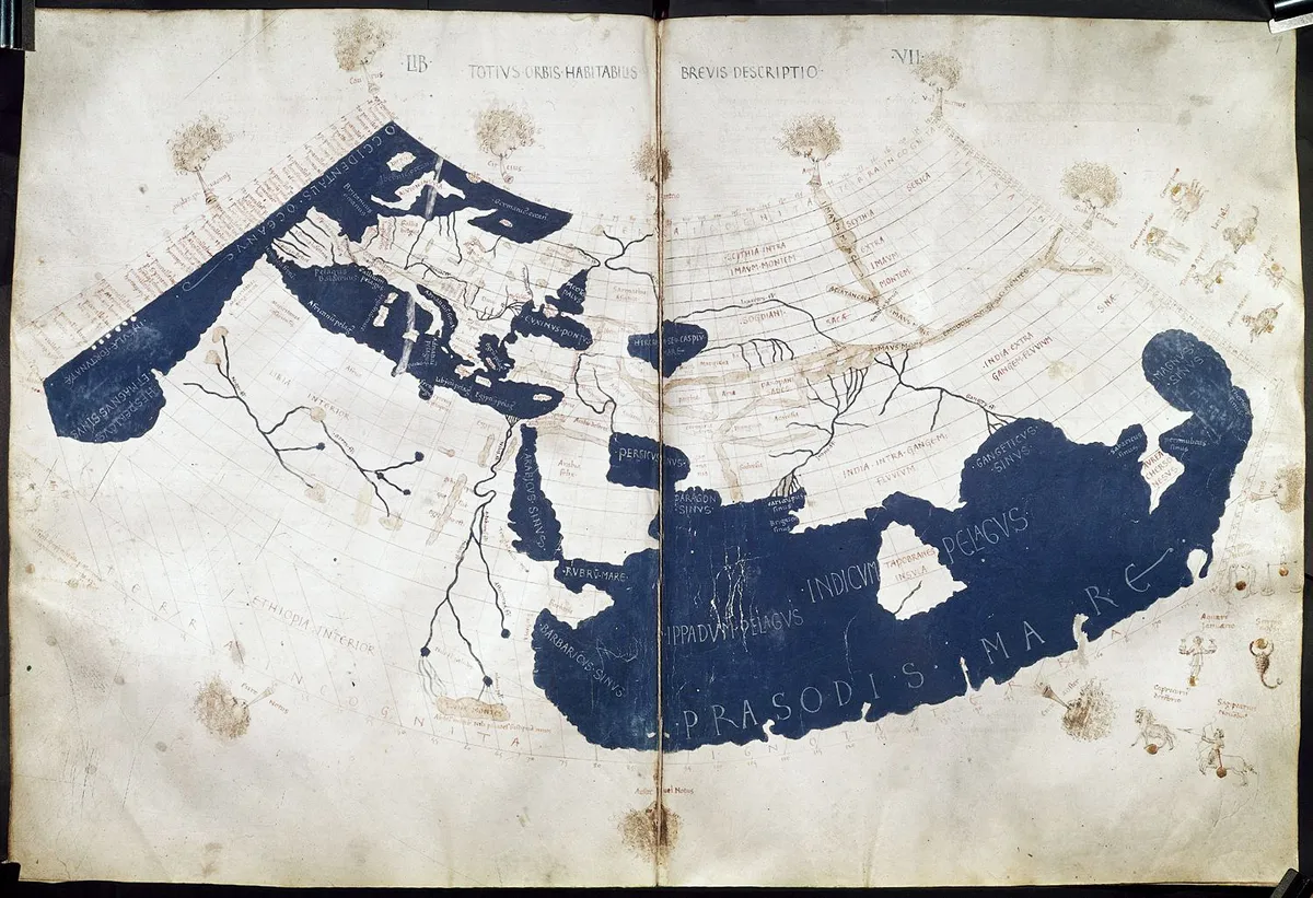
Ptolemy’s objective for the Geography was to catalog, for the first time ever, the latitudes and longitudes of the major cities and landmarks of the inhabited world.
This was the region known in Greek as the ecumene, from which the modern word “ecumenical” derives.
To this end, Ptolemy computed coordinates for locations as far west as the Canary Islands, or 'Islands of the Blest', and as far east as the 'metropolis of the Chinese', a city which may have referred to Luoyang, the capital of the Eastern Han dynasty.
The northernmost extent of his geography was the “latitude of Thule,” a line he drew at 63° north of the equator.
Squashing the sphere
Within the Geography, Ptolemy managed to compile an impressive list of nearly 8,000 latitude and longitude pairs. But the purpose of the Geography wasn’t to make a list. It was to make maps.
In this, Ptolemy, even more than the explorers he described, ventured into truly uncharted terrain.
By being the first to address head- on the mathematical challenges of mapping the Earth’s sphere onto a plane, Ptolemy is rightfully the first true cartographer.
At issue is how to comprehend in the mind’s eye the totality of the Earth’s geography, both large and small, because even an accurate spherical globe shows only half the Earth in any one view.
Meanwhile, on a more granular scale, it would be completely impractical to make a globe big enough to show details helpful to a traveler, like city streets or river crossings.
Flat maps, in principle, can solve both of these problems. And yet, as with most things, you can’t get something for nothing.
It’s simply not possible to transfer points from a sphere to a plane without losing important information in the process.
The simplest flat map converts the Earth’s latitudes and longitudes into evenly spaced, straight lines on a rectangular grid.
While this has the benefit of displaying the entire globe all at once, it doesn’t do a good job showing what the continents really look like or their correct relationships to each other.
The Mercator projection (see below), familiar from school classrooms the world over, partly solves this problem by ensuring that north–south distances are kept equal to east–west distances at every point.
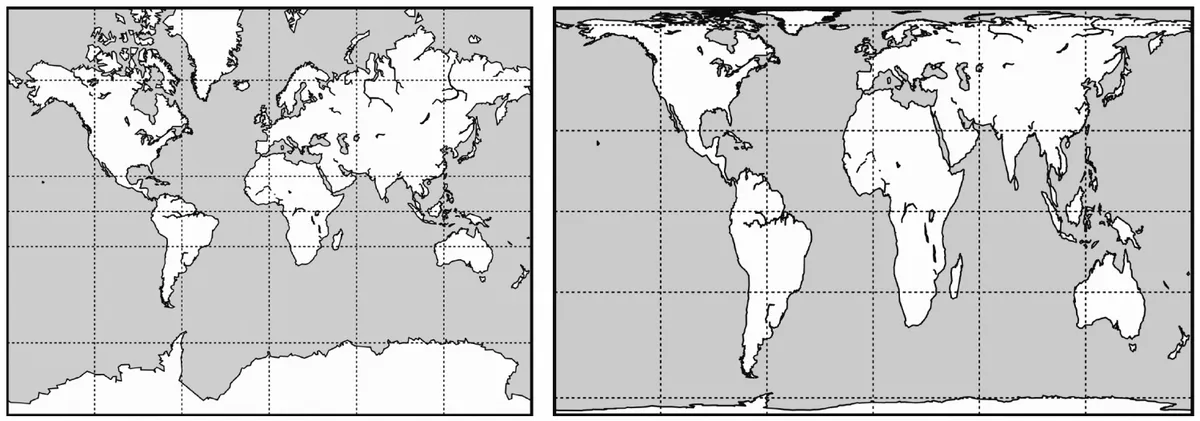
In particular, if you wanted to sail from, say, the Port of Shanghai to the Panama Canal, a Mercator map would tell you the right compass bearing to follow.
This is a really nice property for a map to have, but the tradeoff is that regions near the poles, such as Greenland, now appear enormous.
To fix this problem, the Peters projection (see above) shows the areas of the Earth’s landmasses in their correct proportions to one another.
Since the Peters map diminishes the visual importance of the more northerly countries, it has become popular as a sort of anti- Mercator map.
But the tradeoff here is that it doesn’t represent angles correctly at all. If you were to sail from Shanghai to Panama along the compass bearing taken from a Peters map, you’d end up making landfall near Lima, Peru, some 1,500 miles south of your intended destination.
Unfortunately, it’s not possible, mathematically, to make a flat map that simultaneously preserves angles, like a Mercator projection, and areas, like a Peters projection (although it’s certainly possible to make a map that preserves neither).
All flat maps have to make a compromise. Ptolemy, for his part, experimented with several mapping styles, each of which strikes a different balance of mathematical and visual characteristics.
A few of these styles remain widely used even today. In the Geography, for instance, he presents the first ever description of a conic projection.
Yet terrestrial charts like these of coastlines and capitals were, to Ptolemy, merely a warm- up. There was another sphere, beyond the Earth, whose contours he still wished to trace.
An image of the world
In a separate, short treatise called the Planisphere, of which only an Arabic translation survives, Ptolemy gives a mathematical description of an elegant and versatile mapping technique called stereographic projection.
This technique remains, even today, hugely important in disciplines ranging from mathematics and astronomy to optics, crystallography, and electrical engineering.
Stereographic projection is also the basis of the astrolabe, an ancient and beautiful astronomical instrument and the graphical inspiration for all of the schemes of heaven in this book.
For a basic idea of a stereographic projection, imagine looking down on a globe from above its North Pole, and then squashing it onto its equator.
The visual effect ends up looking like a scoop of ice cream that’s melted onto a warm plate from the bottom out.
Because there’s no limit to how far outward these maps spread, it’s customary to extend them only as far south as the Tropic of Capricorn.
Like the Mercator projection, stereographic projection belongs to the family of maps that preserve angles.
But the special magic of a stereographic projection is that it takes any circle you can draw on a spherical globe, no matter the circle’s size or location, and converts it into a corresponding circle on a flat map.
In other words, stereographic projection keeps circles as circles; it doesn’t transform them into more complicated curves.
Since the various geocentric coordinate systems of astronomy consist entirely of circles drawn on the celestial sphere, a stereographic map provides an elegant way of displaying all of these together at the same time.
Right ascensions and declinations, ecliptic longitudes and ecliptic latitudes, azimuths and elevations, even the Houses of Heaven— on a stereographic map, they’re all drawn as simple, circular arcs.
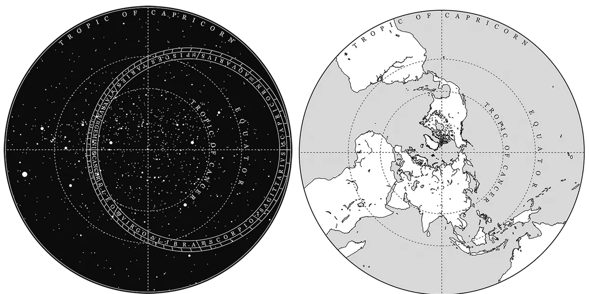
The figure above shows stereographic projections of both the celestial sphere and the more familiar sphere of the Earth.
To make a stereographic mapping of the entire Ptolemaic cosmos, all you would need to do is place the star map directly on top of the Earth map.
The daily revolution of the heavens can then be simulated by keeping the Earth map stationary while the star map rotates clockwise once per day.
This construction of two stacked stereographic maps provides the basic blueprint for an astrolabe.
On an astrolabe, however, the terrestrial map is only implicit. What’s shown instead is the horizontal coordinate grid (that is, the azimuth and elevation lines) for the spot where you happen to be.
No matter where you are on Earth, you have a view of exactly one half of the celestial sphere. The plane of your horizon divides the celestial sphere into two equal hemispheres, and you can see the hemisphere above your head.
What this hemisphere looks like when plotted on a stereographic map centred around the North Pole can be a little tricky to visualise.
The figure below shows horizontal grids suited for observers at four different latitudes.
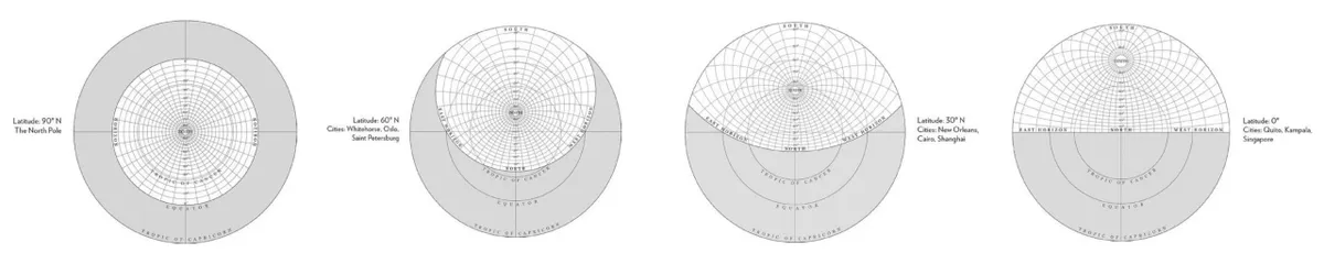
The appearance of the grid at 90° north is probably the easiest one to intuit; the others can then be understood by comparison. In practice, astrolabes would come with several of these plates, which could be swapped in or out depending on where you were.
Plates for latitudes south of the equator could be constructed in a similar way, but the Tropics of Cancer and Capricorn would need to be switched.
Now if, on top of these terrestrial plates, we keep just the ecliptic circle as an abstraction of the celestial map, we’ll end up with an image of the cosmos that’s starting to look a lot like the schemes of heaven which appear in this book.
The most conspicuous difference is that this image would look quite barren without the Sun, Moon, and planets. Unlike Archimedes’ clockwork model of the universe, astrolabes weren’t designed to simulate the complicated orbits of these heavenly bodies.
However, if you had a set of handy planetary tables, like the ones the Almagest taught you how to make, you could look up each planet’s ecliptic coordinates for a given day and mark them on the ecliptic circle, just as we’ve done in our schemes.
Then, by rotating the celestial map clockwise to simulate the sky’s daily rotation, the astrolabe will tell you at what time each heavenly object will appear in different parts of the sky.In particular, the rising time of any star or planet can be determined by noting when, in its rotation, it crosses the horizon line for your latitude.
This remarkable capability is of supreme importance to astrology, and we’ll have more to say about it in the next chapter.
A means to an end?
Without astronomy there can be no astrology. That much is pretty clear. In order to assess the influence of the planets, you first need to have at least some capability of determining where those planets are, were, and will be.
The technological operations of astronomy are the building blocks that enable the abstract ideas of astrology to take shape. And just as a musician understands a piece of music in certain ways a pure listener does not, the ideas of astrology will be understood differently by someone who is familiar with the technological practices that give expression to those ideas.
Insofar as Ptolemy’s Almagest represents the most significant record of these practices, Otto Neugebauer, the historian of science we met earlier, draws a line in the sand: Any serious student of ancient or medieval astronomy must familiarise himself with these details, not only in order properly to appreciate one of the greatest masterpieces of scientific analysis ever written, but also to be able to understand what was common knowledge for every competent astronomer from the second to the seventeenth century. Fighting words, to be sure.
And yet a book like this is hardly the place to get into the intricacies of planetary orbit calculations, ancient or modern. For one thing, astrology is a consumer, not a producer, of astronomical data.
In principle, the only astronomy an ancient astrologer needed to know was how to look up a planet’s coordinates in tables compiled by an ancient astronomer (even if, in practice, these were often the same person).
Similarly, today, we can take for granted that highly accurate astronomical data is never more than a mouse- click away. Specifically, all of the planetary data that I’ve used in this book comes from the HORIZONS online ephemeris system of NASA’s Jet Propulsion Laboratory.
This service provides public access to the same, high-precision data used for interplanetary spacecraft navigation and for generating the astronomical almanacs published each year by the United States Naval Observatory and the United Kingdom Hydrographic Office.
But what about the other side of this relationship? Would astronomy as we know it exist without astrology? The respectable applications of timekeeping, calendar regulation, and navigation have always been the chief motivations for observing the Sun, Moon, and stars.
But the planets? Historically, there was never a single application that required knowledge of the positions of the planets other than astrology.
And it was the challenge of accurately predicting the orbits of the planets that ultimately gave rise to the scientific revolution and, from there, our modern technological world.
Of course, it’s possible that for centuries astronomers felt compelled to address the minor inconsistencies in the orbit calculations of, say, Mars for purely theoretical reasons.
I wouldn’t bet too much on it, though, especially when so many of these same astronomers were so deeply committed to addressing the practical problems of astrology.
In this, they were only following in the footsteps of the greatest of their predecessors, Ptolemy.
Ptolemy's astrology
That Ptolemy, the most famous scientist of the ancient world, also wrote a book on astrology is a seemingly minor detail that, upon reflection, probably single- handedly ensured astrology’s survival.
It’s as if Einstein had followed up his theory of relativity with a book on the physics of crystal healing (which, to be clear, he most assuredly did not).
A millennium and a half later, when Copernicus arrived at the University of Bologna, Ptolemy’s astrology book, the Tetrabiblos, was still required reading in the astronomy curriculum, which, in turn, was mandatory for anyone pursuing a medical degree.
(This connection between astrology and medicine is one of long- standing importance; for many centuries, physicians were expected to make their diagnoses and time their prescriptions according to the planets.)
Like his geography, Ptolemy framed astrology as a natural extension of his astronomy. Or, as Ptolemy put it, his Tetrabiblos was about making predictions “by means of astronomy” (δι’ στρονομίας).
According to Ptolemy, these predictions came in two varieties. The first, treated earlier in the Almagest, concerned the future positions of the stars and planets.
The second— the subject of the Tetrabiblos—concerned the effects of these heavenly bodies on their surroundings.
Ptolemy’s use of the word astronomia, “astronomy,” in the opening of the Tetrabiblos is significant, because it contributed to the thorough blurring of “astronomy” and “astrology” that persisted right through the end of the scientific revolution.
Bucking the convention established by Aristotle, Ptolemy never makes use of the word astrologia. Even more surprising is that in the Almagest, the single most important astronomy book prior to Copernicus, Ptolemy never uses the word astronomia either.
Instead, Ptolemy insisted that the Almagest was explicitly a work of “mathematics.” And he explicitly identifies his predecessors, including the great Hipparchus, as “mathematicians.” (And let’s not forget that Ptolemy’s original title for the Almagest was the Mathematical Syntaxis.)
Meanwhile, in literary, nontechnical writings from the Roman Empire, such as Petronius’s Satyricon, a “mathematician” (mathematicus) was always and unambiguously an astrologer.
All of this is extremely confusing. But that’s exactly the point. The modern distinction between astronomy and astrology is very difficult to project backward into the past.
This isn’t because the distinction wasn’t acknowledged conceptually— it was— but more because there was rarely any distinction between an astronomer and an astrologer professionally. Indeed, Ptolemy himself was the model for this.
For Ptolemy, the more meaningful distinction was within his second type of astronomical predictions— what we would call astrology— which he divided into two subcategories: “general” predictions about the weather, the environment, and the destinies of cities and countries; and “genethlialogical” predictions (from the Greek word for “birthday”) about the destinies of individuals.
This notion of “two astrologies” or “both astrologies,” meaning general and individual, was revived during the Renaissance and referenced frequently by thinkers like Tycho Brahe and Johannes Kepler.
In Greek, Tetrabiblos means “The Four Books.” This signifies only that the work was divided into four extended sections. The Tetrabiblos is extremely detailed and, on this account, extremely fascinating.
But since Ptolemy insists on keeping the Tetrabiblos on a high philosophical plane, it’s definitely not the book you would choose as a handy, practical guide.
Given its almost complete lack of examples, trying to learn about astrology from the Tetrabiblos is a bit like trying to learn how to cook from a cookbook with no recipes.
Instead, the Tetrabiblos seems to have functioned as a sort of astrological referee, providing an “official” opinion on topics that were otherwise subject to a range of conflicting interpretations.
Extract used with permission. A Scheme of Heaven is available from Profile Books.

 in the astronomical observatory of Alexandria, Egypt. La-vie-des-savants-illustres by Louis Figuier, 1866 Private collection (Photo by Leemage/Corbis via Getty Images)")
