It is 50 years since mankind set foot on the Moon, however our connection with our closest neighbour began far earlier.
Through the centuries people have sketched the Moon, these sketches became maps and these maps became ever more accurate. Such maps were crucial in the success of the Apollo 11 Moon landing and have played a huge role in both lunar and celestial exploration.
In this gallery, we take a look at some of the maps and other paraphernalia that will be on display at The Map House exhibition “The Mapping of The Moon: 1669 - 1969” from 21 June 2019 until 21 August 2019. In a celebration of mankind’s fascination with the Moon and beyond.
We look at how our understanding of the Moon has significantly developed in the last 350 years. Beginning with simple observations with the naked eye and leading up to exploring the lunar surface with our own feet and advanced robotic technology.
For more information about the exhibit visit The Map House website.
Der Mond, La Lune, The Moon, La Luna
Created by Hans Schwarzenback and published by Hallwag in 1969. The map celebrates The Apollo 11 mission and the landing site is marked with a red dot.
Tabula Selenographica
Published in 1710 this map depicts the Moon's surface as a comparative analysis of the topography and nomenclature of Hevelius and Riccioli. Johannes Hevelius (1611-1687) founded Selenography. Giovanni Battista Riccioli (1598 - 1671) introduced current lunar nomenclature, naming features such as the Sea of Tranquillity, the Apollo 11 landing site.
Stars for July
Created by Dr Richard Anthony Proctor and published in 1884, this map depicts the stars location in the night sky of July. Proctor (1837 - 1888) was an English astronomer known for producing one of the earliest maps of Mars. Using old drawings of Mars dating back to 1666, Proctor attempted to calculate the sidereal day, his final estimate 24h 37m 22.713s was very close to modern day value of 24h 37m 22.663s.
North American Rockwell Map of the Moon
Produced by aerospace manufacturer North American Rockwell and published in 1969, prior to the Apollo 11 Moon landing in July. This map depicts the five potential landing sites as well as a diagram of NASA's Lunar Landing Mission.
Lunar Wall Mosaic
Created by the Air Force Aeronautical Chart and Information Center, in the heart of the Space Race, The Lunar Wall Mosaic is a map compiled from thousands of lunar photographs. Detailed maps like this were crucial to the success of projects like Apollo 11.
Celestial Globe
This globe was produced in 1920 by the Räthgloben publishing house. Celestial globes are designed to show the apparent positions of the stars in the sky.
Armillary Sphere
Produced in 1872 by Henry L Bryant (1812-1881). Armillary spheres are models of objects in the sky (on the celestial sphere) cantered on the Earth or the Sun. Unbeknown to many, the flag of Portugal features an armillary sphere.
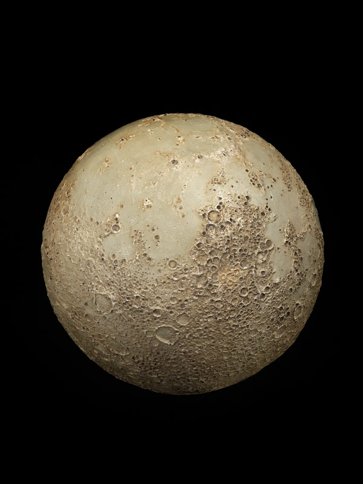
Rare Lunar Relief Globe
Produced by Educational Frontiers in 1969 to commemorate the successful Apollo 11 mission.
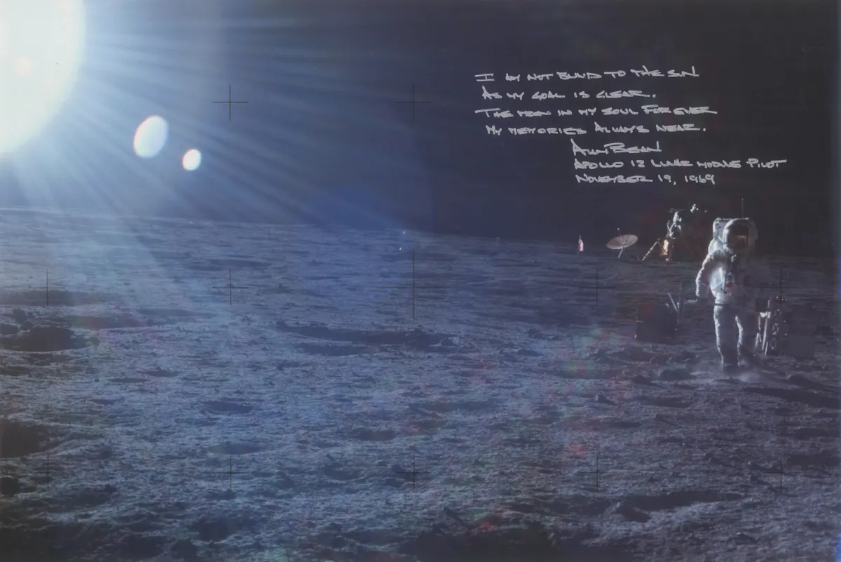
Alan Bean during Apollo 12
Taken 19 November 1969, a signed photograph of astronaut Alan Bean, Lunar Module Pilot, on the surface of the Moon during Apollo 12. Alongside Bean's signature is a quote from author Rudyard Kipling.
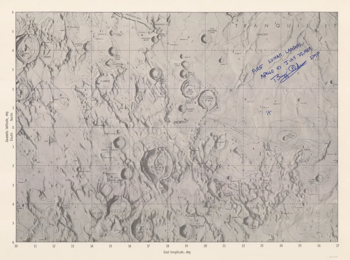
Signed map of Apollo 11 landing site
This 'internal use only' map, published in 1969 depicts the Apollo 11 landing site in the Sea of Tranquillity and is signed by astronaut Buzz Aldrin Lunar Module Pilot Apollo 11.
Réduction de la grande Carte de la Lune
Published in 1788, this is a reduction of Cassini IV's reissue of his great-grandfather's rare lunar map. Cassini made approximately 60 drawings of the Moon between 1671-1679, with the assistance of artists Sebastien Leclerc and Jean Patigny.
Relief-map of the Moon
Produced by Falk-Verlag and published in 1968. The relief documented is as seen through a telescope and shown by shading and land form drawings.
Typus Corporis Lunaris
Published in 1669, the map was based on observations of Anthanasius Kircher and Christoph Scheiner in 1636 and 1650. Kircher (1602 - 1680) a German Jesuit scholar and polymath with an enormous range of interests. Scheiner (1573 - 1650) is famed for inventing the copying instrument, pantograph.
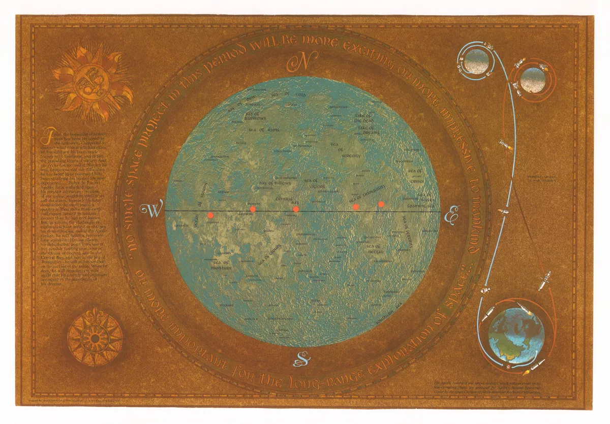
The conquest of space
Published by Hallway in 1969. The map describes the exploration of space depicting the moon orbit, planetary orbits, relative sizes of planets, satellites and spacecraft. The map includes impotant missions from 1957 - 1969
Lunar Wall Mosaic
Created by the Air Force Aeronautical Chart and Information Center, in the heart of the Space Race, The Lunar Wall Mosaic is a map compiled from thousands of lunar photographs. Detailed maps like this were crucial to the success of projects like Apollo 11.
This website is owned and published by Our Media Ltd. www.ourmedia.co.uk